Coastal Management Case Study - Holderness
Coastal erosion in holderness.
The Holderness coast is located next to the city of Hull in the north-east of England. Each year, the Holderness Coast retreats 1-2 metres. The area is particularly vulnerable to erosion because of:


Strong prevailing winds
- Strong prevailing winds create destructive waves that can do more damage to the coast.
- The prevailing winds also mean that any eroded material moves away from the place that was eroded (leaving the soft rock exposed).
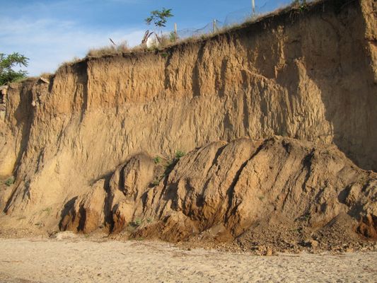
Clay cliffs
- The Holderness Coast is made of boulder clay.
- This is very soft and easy to erode.
- Heavy rainfall can cause mass movements in the boulder clay cliffs.
Coastal Management in Holderness
In 1991, a £2 million project built rock groynes and rock revetments at Mappleton in the Holderness coast. These are examples of hard engineering.
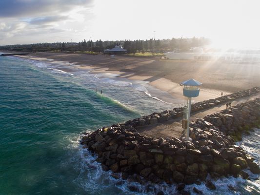
Rock groynes
- The rock groynes tried to stop sediment being carried away from the Holderness Coast and tried to create a larger beach to protect the land behind.
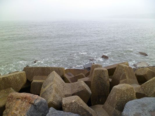
Rock armour
- Rock armour was placed at the foot of the cliffs.
- The rock armour is meant to absorb some of the waves' energy, instead of the coast or cliffs.
What are the Results & Effects of Coastal Management at Mappleton?
The cliffs at Mappleton now erode at 1-2 metres per year, instead of the 7-10 metres before 1991. Mappleton now has a larger beach, however, there have been some negative effects:
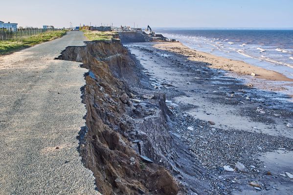
Area south of Mappleton
- The area south of Mappleton is experiencing faster coastal erosion as a byproduct.
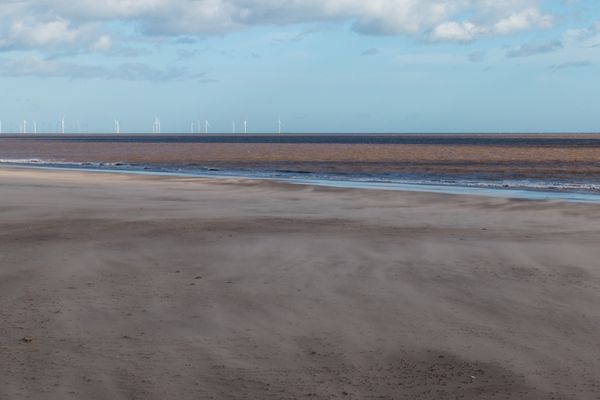
Spurn Point
- The Spurn Point area south, has become less secure.
- Less material is washed down the Holderness Coast.
- Some Hebridean Sheep were washed away and killed. People are now warned not to visit the Point at some times of year, or they too could be washed away.
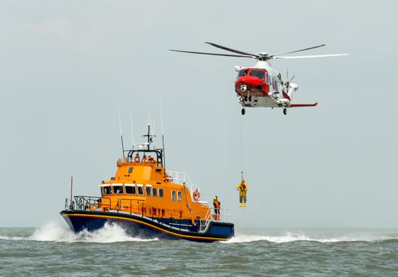
Spurn Point lifeboat & visitor's centre
- £471,000 was spent on a visitor's centre which could become less accessible over time.
- Lifeboat services also operate from Spurn Point.
1 The Challenge of Natural Hazards
1.1 Natural Hazards
1.1.1 Types of Natural Hazards
1.1.2 Hazard Risk
1.1.3 Consequences of Natural Hazards
1.1.4 End of Topic Test - Natural Hazards
1.1.5 Exam-Style Questions - Natural Hazards
1.2 Tectonic Hazards
1.2.1 Tectonic Plates
1.2.2 Tectonic Plates & Convection Currents
1.2.3 Plate Margins
1.2.4 Volcanoes
1.2.5 Effects of Volcanoes
1.2.6 Responses to Volcanic Eruptions
1.2.7 Earthquakes
1.2.8 Earthquakes 2
1.2.9 Responses to Earthquakes
1.2.10 Case Studies: The L'Aquila & Kashmir Earthquakes
1.2.11 Earthquake Case Study: Chile 2010
1.2.12 Earthquake Case Study: Nepal 2015
1.2.13 Living with Tectonic Hazards 1
1.2.14 Living with Tectonic Hazards 2
1.2.15 End of Topic Test - Tectonic Hazards
1.2.16 Exam-Style Questions - Tectonic Hazards
1.2.17 Tectonic Hazards - Statistical Skills
1.3 Weather Hazards
1.3.1 Global Atmospheric Circulation
1.3.2 Surface Winds
1.3.3 UK Weather Hazards
1.3.4 Tropical Storms
1.3.5 Features of Tropical Storms
1.3.6 Impact of Tropical Storms 1
1.3.7 Impact of Tropical Storms 2
1.3.8 Tropical Storms Case Study: Katrina
1.3.9 Tropical Storms Case Study: Haiyan
1.3.10 UK Weather Hazards Case Study: Somerset 2014
1.3.11 End of Topic Test - Weather Hazards
1.3.12 Exam-Style Questions - Weather Hazards
1.3.13 Weather Hazards - Statistical Skills
1.4 Climate Change
1.4.1 Evidence for Climate Change
1.4.2 Causes of Climate Change
1.4.3 Effects of Climate Change
1.4.4 Managing Climate Change
1.4.5 End of Topic Test - Climate Change
1.4.6 Exam-Style Questions - Climate Change
1.4.7 Climate Change - Statistical Skills
2 The Living World
2.1 Ecosystems
2.1.1 Ecosystems
2.1.2 Ecosystem Cascades & Global Ecosystems
2.1.3 Ecosystem Case Study: Freshwater Ponds
2.2 Tropical Rainforests
2.2.1 Tropical Rainforests - Intro & Interdependence
2.2.2 Adaptations
2.2.3 Biodiversity of Tropical Rainforests
2.2.4 Deforestation
2.2.5 Case Study: Deforestation in the Amazon Rainforest
2.2.6 Sustainable Management of Rainforests
2.2.7 Case Study: Malaysian Rainforest
2.2.8 End of Topic Test - Tropical Rainforests
2.2.9 Exam-Style Questions - Tropical Rainforests
2.2.10 Deforestation - Statistical Skills
2.3 Hot Deserts
2.3.1 Overview of Hot Deserts
2.3.2 Biodiversity & Adaptation to Hot Deserts
2.3.3 Case Study: Sahara Desert
2.3.4 Desertification
2.3.5 Case Study: Thar Desert
2.3.6 End of Topic Test - Hot Deserts
2.3.7 Exam-Style Questions - Hot Deserts
2.4 Tundra & Polar Environments
2.4.1 Overview of Cold Environments
2.4.2 Adaptations in Cold Environments
2.4.3 Biodiversity in Cold Environments
2.4.4 Case Study: Alaska
2.4.5 Sustainable Management
2.4.6 Case Study: Svalbard
2.4.7 End of Topic Test - Tundra & Polar Environments
2.4.8 Exam-Style Questions - Cold Environments
3 Physical Landscapes in the UK
3.1 The UK Physical Landscape
3.1.1 The UK Physical Landscape
3.2 Coastal Landscapes in the UK
3.2.1 Types of Wave
3.2.2 Weathering & Mass Movement
3.2.3 Processes of Erosion & Wave-Cut Platforms
3.2.4 Headlands, Bays, Caves, Arches & Stacks
3.2.5 Transportation
3.2.6 Deposition
3.2.7 Spits, Bars & Sand Dunes
3.2.8 Case Study: Landforms on the Dorset Coast
3.2.9 Types of Coastal Management 1
3.2.10 Types of Coastal Management 2
3.2.11 Coastal Management Case Study - Holderness
3.2.12 Coastal Management Case Study: Swanage
3.2.13 Coastal Management Case Study - Lyme Regis
3.2.14 End of Topic Test - Coastal Landscapes in the UK
3.2.15 Exam-Style Questions - Coasts
3.3 River Landscapes in the UK
3.3.1 The River Valley
3.3.2 River Valley Case Study - River Tees
3.3.3 Erosion
3.3.4 Transportation & Deposition
3.3.5 Waterfalls, Gorges & Interlocking Spurs
3.3.6 Meanders & Oxbow Lakes
3.3.7 Floodplains & Levees
3.3.8 Estuaries
3.3.9 Case Study: The River Clyde
3.3.10 River Management
3.3.11 Hard & Soft Flood Defences
3.3.12 River Management Case Study - Boscastle
3.3.13 River Management Case Study - Banbury
3.3.14 End of Topic Test - River Landscapes in the UK
3.3.15 Exam-Style Questions - Rivers
3.4 Glacial Landscapes in the UK
3.4.1 Erosion
3.4.2 Landforms Caused by Erosion
3.4.3 Landforms Caused by Transportation & Deposition
3.4.4 Snowdonia
3.4.5 Land Use in Glaciated Areas
3.4.6 Tourism in Glacial Landscapes
3.4.7 Case Study - Lake District
3.4.8 End of Topic Test - Glacial Landscapes in the UK
3.4.9 Exam-Style Questions - Glacial Landscapes
4 Urban Issues & Challenges
4.1 Urban Issues & Challenges
4.1.1 Urbanisation
4.1.2 Urbanisation Case Study: Lagos
4.1.3 Urbanisation Case Study: Rio de Janeiro
4.1.4 UK Cities
4.1.5 Case Study: Urban Regen Projects - Manchester
4.1.6 Case Study: Urban Change in Liverpool
4.1.7 Case Study: Urban Change in Bristol
4.1.8 Sustainable Urban Life
4.1.9 End of Topic Test - Urban Issues & Challenges
4.1.10 Exam-Style Questions - Urban Issues & Challenges
4.1.11 Urban Issues -Statistical Skills
5 The Changing Economic World
5.1 The Changing Economic World
5.1.1 Measuring Development
5.1.2 Classifying Countries Based on Wealth
5.1.3 The Demographic Transition Model
5.1.4 Physical & Historical Causes of Uneven Development
5.1.5 Economic Causes of Uneven Development
5.1.6 How Can We Reduce the Global Development Gap?
5.1.7 Case Study: Tourism in Kenya
5.1.8 Case Study: Tourism in Jamaica
5.1.9 Case Study: Economic Development in India
5.1.10 Case Study: Aid & Development in India
5.1.11 Case Study: Economic Development in Nigeria
5.1.12 Case Study: Aid & Development in Nigeria
5.1.13 Economic Development in the UK
5.1.14 Economic Development UK: Industry & Rural
5.1.15 Economic Development UK: Transport & North-South
5.1.16 Economic Development UK: Regional & Global
5.1.17 End of Topic Test - The Changing Economic World
5.1.18 Exam-Style Questions - The Changing Economic World
5.1.19 Changing Economic World - Statistical Skills
6 The Challenge of Resource Management
6.1 Resource Management
6.1.1 Global Distribution of Resources
6.1.2 Food in the UK
6.1.3 Water in the UK 1
6.1.4 Water in the UK 2
6.1.5 Energy in the UK
6.1.6 Resource Management - Statistical Skills
6.2.1 Areas of Food Surplus & Food Deficit
6.2.2 Food Supply & Food Insecurity
6.2.3 Increasing Food Supply
6.2.4 Case Study: Thanet Earth
6.2.5 Creating a Sustainable Food Supply
6.2.6 Case Study: Agroforestry in Mali
6.2.7 End of Topic Test - Food
6.2.8 Exam-Style Questions - Food
6.2.9 Food - Statistical Skills
6.3.1 The Global Demand for Water
6.3.2 What Affects the Availability of Water?
6.3.3 Increasing Water Supplies
6.3.4 Case Study: Water Transfer in China
6.3.5 Sustainable Water Supply
6.3.6 Case Study: Kenya's Sand Dams
6.3.7 Case Study: Lesotho Highland Water Project
6.3.8 Case Study: Wakel River Basin Project
6.3.9 Exam-Style Questions - Water
6.3.10 Water - Statistical Skills
6.4.1 Global Demand for Energy
6.4.2 Factors Affecting Energy Supply
6.4.3 Increasing Energy Supply: Renewables
6.4.4 Increasing Energy Supply: Non-Renewables
6.4.5 Carbon Footprints & Energy Conservation
6.4.6 Case Study: Rice Husks in Bihar
6.4.7 Exam-Style Questions - Energy
6.4.8 Energy - Statistical Skills
Jump to other topics

Unlock your full potential with GoStudent tutoring
Affordable 1:1 tutoring from the comfort of your home
Tutors are matched to your specific learning needs
30+ school subjects covered
Types of Coastal Management 2
Coastal Management Case Study: Swanage
The Holderness Coast is one of Europe’s fastest eroding coastlines. The average annual rate of erosion is around 2 metres per year. The main reason for this is because the bedrock is made up of till (soft clay). This material was deposited by glaciers around 12,000 years ago.
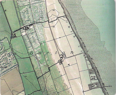
The coastline stretches along the coast of the East Riding of Yorkshire, known as Holderness, from Flamborough Head in the North, to Spurn Head in the south. Since Roman times, the Holderness Coast has retreated 4 km – at least 29 villages have been lost to the sea.
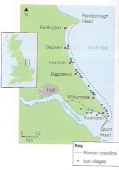
Why is erosion a problem?
Rates of erosion vary in places due to a mixture of human and physical factors. These can change in short and long term. There are three main reasons why Holderness is retreating:
• Geology (Figure 3)
• Longshore drift and beach material
The Holderness Coastline is made up of soft boulder clays (tills) left after the retreat of the Devensian ice sheets about 12 000 years ago. They can be seen on the coast, being rapidly eroded by the sea. To look at, they are a mass of brown clay containing pieces of rock (erratics) brought here by the glaciers from Scandinavia, Scotland, the Lake District and Northeast England. These soft, recent deposits sit on a platform of chalk which slopes away gently to the east.
This is how far the waves have travelled. Holderness is exposed to wind and waves from the north-east, with a fetch of 500 to 800 km across the North Sea. This is not that far and would normally cause large waves but other factors increase their size:
• Currents (or swell) move northwards around the UK from the Atlantic and into the North Sea. The Atlantic’s fetch is 5000km so it’s currents add even more energy to the waves. This causes powerful destructive waves.
• Weather systems and winter storms in the North Sea are often intense. The low pressure raises the sea level, producing higher tides than normal and the storms add energy to the waves, especially in storms.
• The sea floor is deep in the North Sea, meaning waves hit the coast relatively fast and are not slowed down by friction.
Longshore Drift and Beach Material
• The beaches here are the main problem. Boulder clay erodes very easily and produces very small, fine clay particles, these are easily transported by longshore drift out to sea and along the coast, rather than accumulating in front of the cliffs, forming a layer of protection from the waves. The beaches are narrow and fail to absorb the wave energy, during high tide there is not enough beach and waves hit the base of the cliffs.
• Tides flow to the south, transporting material along the coast. There is an imbalance as the harder chalk up the coast does not provide enough material for places like Hornsea so backwash removes more than what is deposited by swash.
http://www.bbc.co.uk/education/clips/z8jfb9q

Why Manage?
ECONOMIC IMPACTS OF EROSION:
• Numbers of visitors to areas along of this coastline has dropped.
• Some settlements unable to maintain a viable population to warrant shops.
• Money has to be spent on coastal management and protection.
• The Gas Terminal in Easington, which supplies 25% of Britain’s gas, is at risk.
• 80000m2 of farmland is lost each year, this has a huge effect on farmer’s livelihoods.
• It’s predicted that 200 homes and several roads will fall into the sea by 2100 .
SOCIAL IMPACTS OF EROSION:
• Around 30 villages have been lost since Roman times, meaning homes and businesses have been lost.
• Many of the settlements rely heavily on tourism, as facilities close down the settlements are unable to maintain a good population.
• Properties under threat of erosion lose their value leaving owners with negative equity. There is no financial help to aid people as no compensation is paid out for the loss of private property or land caused by coastal erosion in England.
• The East Riding Coastal Fund has been set up to aid people.
ENVIRONMENTAL IMPACTS OF EROSION:
• Wildlife behind Spurn Point is losing diversity as the environment cannot support many species due to the lack of sediment. Spurn Head is a spit and salt marsh at the southern tip of the coastline.
• Some SSSIs (Sites Of Special Scientific Interest) are threatened by erosion.
Coastal Management
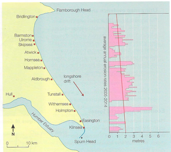
- The graph shows erosion rates opposite to their specific locations. Where there are gaps, it means coastal defences are present and working. You can see that there are higher rates of erosion directly south of these defences.
- This is due to the flow of beach material by longshore drift being stopped by protection methods such as groynes, sea walls and rock armour/rip rap.
- Hornsea may well be protected but places like Mappleton, directly south are starved of material are eroding at excessive rates, this is called terminal groynes syndrome.
- 0 Shopping Cart

Holderness Coast Landforms
AQA GCSE Geography > Physical Landscapes in the UK > Holderness Coast Landforms
The Holderness Coast in East Yorkshire stretches 61 kilometres from Flamborough Head in the North to Spurn Point in the South.
The coastline is one of the fastest eroding in Europe, leading to the formation of a range of coastal landforms characterised by erosion and deposition .
The Geology of the Holderness Coast
Underlying the Holderness Coast is bedrock made up of Cretaceous Chalk. However, in most places, this is covered by glacial till deposited over 18,000 years ago. This soft boulder clay is being rapidly eroded.
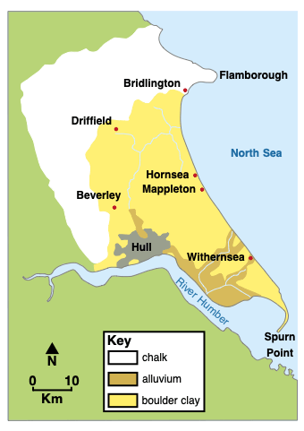
The geology of the Holderness Coast
Landforms of erosion and deposition on the Holderness Coast
Selwicks bay, flamborough.
Flamborough Head is a headland that juts out into the North Sea. It is formed from chalk, a resistant rock.
Several bays are located along Flamborough Head, where the sea has eroded weaknesses in the chalk cliffs. Selwicks Bay is one example. The bay contains a range of coastal landforms of erosion and deposition.
The cliffs here are formed from chalk. Overlying the chalk is a layer of boulder clay.
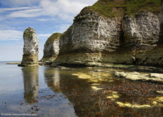
Erosional processes, including hydraulic action and abrasion , have formed many coastal landforms within Selwicks Bay, including steep cliffs, wave-cut notches, a wave-cut platform, a stack known locally as Stack Adam, and coastal arches.
Landforms of deposition at Flamborough are limited to small beaches formed by the erosion and weathering of cliff material. These beaches consist of chalk from collapsed cliffs and weathering, pebbles from the eroded boulder clay, and sand that has formed from abrasion and attrition .
Landforms of deposition
Beaches have formed along the Holderness Coast due to the deposition of sand and shingle transported by longshore drift . The eroded material is transported from north to south along the coast. Beach material has accumulated at locations such as Hornsea, Withernsea, and Mappleton due to the construction of wood and stone groynes, which trap sediment .
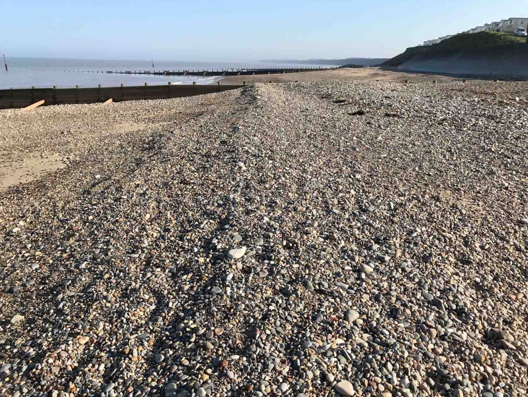
Sand and shingle beach at Hornsea
Spurn Point
In contrast to Flamborough Head, Spurn Point is home to a wide range of coastal landforms of deposition. Spurn Point is a coastal spit formed by the deposition of sediment transported along the Holderness Coast from north to south by longshore drift.
Where the coastline changes direction, material has been deposited to form the sandy spit.
Spurn Point is curved, with a hooked end, because the wind and waves coming from a secondary direction push the tip of the land in that direction, giving it this unique appearance.
Beach material is blown up the beach by the wind, forming sand dunes, which stretch almost the length of Spurn Point and have helped stabilise the spit.
Salt marshes have formed behind Spurn Point, as the River Humber deposits silt and mud in this sheltered estuary area.
The Holderness Coast in East Yorkshire spans 61 kilometres from Flamborough Head to Spurn Point and is known for its rapid erosion.
The region’s geology consists of Cretaceous Chalk covered by glacial till, primarily soft boulder clay, which is eroding quickly.
Flamborough Head, a chalk headland, exhibits various coastal landforms like cliffs, wave-cut notches, a wave-cut platform, a stack, and coastal arches due to erosional processes.
At Flamborough, deposition landforms are limited to small beaches formed from collapsed cliffs and eroded boulder clay.
Spurn Point, in contrast, has a wide range of coastal deposition landforms like a sandy spit, sand dunes, and salt marshes, formed by longshore drift and river deposits.
Spurn Point’s unique curved shape results from the influence of wind and waves coming from a secondary direction.
Share this:
- Click to share on Twitter (Opens in new window)
- Click to share on Facebook (Opens in new window)
- Click to share on Pinterest (Opens in new window)
- Click to email a link to a friend (Opens in new window)
- Click to share on WhatsApp (Opens in new window)
- Click to print (Opens in new window)
Please Support Internet Geography
If you've found the resources on this site useful please consider making a secure donation via PayPal to support the development of the site. The site is self-funded and your support is really appreciated.
Search Internet Geography
Top posts and pages.
Latest Blog Entries
Pin It on Pinterest
- Click to share
- Print Friendly

IMAGES
VIDEO
COMMENTS
Infamous for being the most rapidly retreating coastline in Europe. A look at what can be done to save land and its effects on the rest of the coastline.See...
'Cup of Tea & Case Studies are covering the popular case study on the causes, impacts and management of coastal erosion along the Holderness Coast, East York...
Where is the Holderness Coast? What defences are found along the coastline? What is the coastal management at Mappleton? This is the forty-second video for t...
The Holderness Coast is located on the east coast of England. It extends 61km from Flamborough in the north to Spurn Point in the south. Lost settlements on the Holderness Coast. The Holderness Coastline is one of Europe's fastest eroding at an average annual rate of around 2 metres. This is around 2 million tonnes of material every year.
The coastline is rapidly eroding at an average of 1.8 metres a year. There are several reasons why the coast at Holderness is eroding so quickly: Bridlington is protected by a 4.7 km long sea wall ...
In the case of Holderness, waves approach the coastline at an angle between 34.9 degrees and 14.4 degrees (Pye & Blott, 2015). ... Withernsea, a coastal town located towards the southern end of the Holderness coastline, has implemented a combination of concrete sea walls and timber groynes, as well as rock armour, with the first significant ...
Case - study - The Holderness Coastline. The Holderness coastline of the East Riding of Yorkshire is widely regarded as one of the fastest eroding coastlines in Europe and has been so since the last ice age. Despite this, it is the home to several towns and many villages and a thriving tourism and fishing industry. ... Mappleton Aerial Videos ...
The Holderness Coastline. Skip to content. Coastal Management Case Study
The Holderness cliffs. These boulder clay cliffs are formed from material left by ice sheets. They are retreating at an average rate of 1.8 metres per year (ten times the rate in the chalk cliffs). This results from the combined effects of land (cliff-face) processes and sea (cliff-foot) erosion. On land, rainwater enters the clay and the ...
Withernsea Case Study Location. Withernsea is a seaside resort town on the Holderness Coast, situated approximately 10 miles (16 km) north of Spurn Point and 17 miles south of Hornsea where the B1242 meets the A1033.The town is surrounded by rich agricultural land and yet sits close to the cliffs and the North Sea.
A GCSE case study of coastal erosion and its management, from http://www.coolgeography.co.uk
Spurn Point Case Study Location of Spurn. The area known as Spurn forms the southern extremity of the Holderness coast and includes the unique feature of Spurn Point, a sand and shingle spit 5.5km long, reaching across the mouth of the Humber. Geology of Spurn. Spurn is made up of the material which has been transported along the Holderness Coast.
The Holderness coast is located next to the city of Hull in the north-east of England. Each year, the Holderness Coast retreats 1-2 metres. ... 3.2.11 Coastal Management Case Study - Holderness. 3.2.12 Coastal Management Case Study: Swanage. 3.2.13 Coastal Management Case Study - Lyme Regis. 3.2.14 End of Topic Test - Coastal Landscapes in the UK.
The Holderness Coast is one of Europe's fastest eroding coastlines. The average annual rate of erosion is around 2 metres per year. The main reason for this is because the bedrock is made up of till (soft clay). This material was deposited by glaciers around 12,000 years ago. The coastline stretches along the coast of the East Riding of ...
The Holderness Coastline is the fastest eroding coast in the UK with in a single storm hundreds of thousands of tonnes of rock being eroded. There are three main reasons why this is the case, these are: 1. Geology - boulder clay and glacial sands make up a large amount of the coast. 2.
- Headlands (Flamborough Head) - Wave cut platforms / notches (Flamborough Head) - Spit (Spurn Point, where 3% of the material eroded from the Holderness Coast is deposited annually. Sand dunes are formed, which stabalize it) - Bays (Selwicks Bay has Adam the stack, a wavecut knotch from abrasion and hydraulic action, a beach made of eroded clif material, and a cave) - Salt marsh behind Spurn ...
The first of two short videos with me explaining the factors that affect the erosion along the Holderness Coast
Massive, made of rocks or Traditional solution to protect Very costly, foundations easily Holiday resorts, e.g. Hornsea and concrete, used to absorb waves. valuable resources, high-risk undermined of built on beaches, or Withernsea Some types can act as Baffles property or densely populated where LSD operates areas.
A case study into the Holderness Coast for Edexcel GCSE Geography (9-1).
A level Geography: Coasts case study, The Holderness coast. Introduction. Click the card to flip 👆. - the coast is 60km long. - The Holderness coastline is in the North of England and runs between spurn head and Flamborough head. - Approximately, 3 miles of land has been lost since Roman times, including 23 towns/ villages.
1. Worst coastal erosion in Europe. 2. Coastline has retreated by almost 400m in the last 2,000 years. 3. ~1 million years ago the Yorkshire coastline was a line of chalk cliffs. During the Ice Age, deposits of soft boulder clay (easily eroded by wave action at a rate of 2m per year) were built up against the cliffs to form the new coastline.
The Holderness Coast in East Yorkshire spans 61 kilometres from Flamborough Head to Spurn Point and is known for its rapid erosion. The region's geology consists of Cretaceous Chalk covered by glacial till, primarily soft boulder clay, which is eroding quickly. Flamborough Head, a chalk headland, exhibits various coastal landforms like cliffs ...
About Press Copyright Contact us Creators Advertise Developers Terms Privacy Policy & Safety How YouTube works Test new features NFL Sunday Ticket Press Copyright ...